Vitosha Mountain day hikes: routes, difficulty, and what to expect
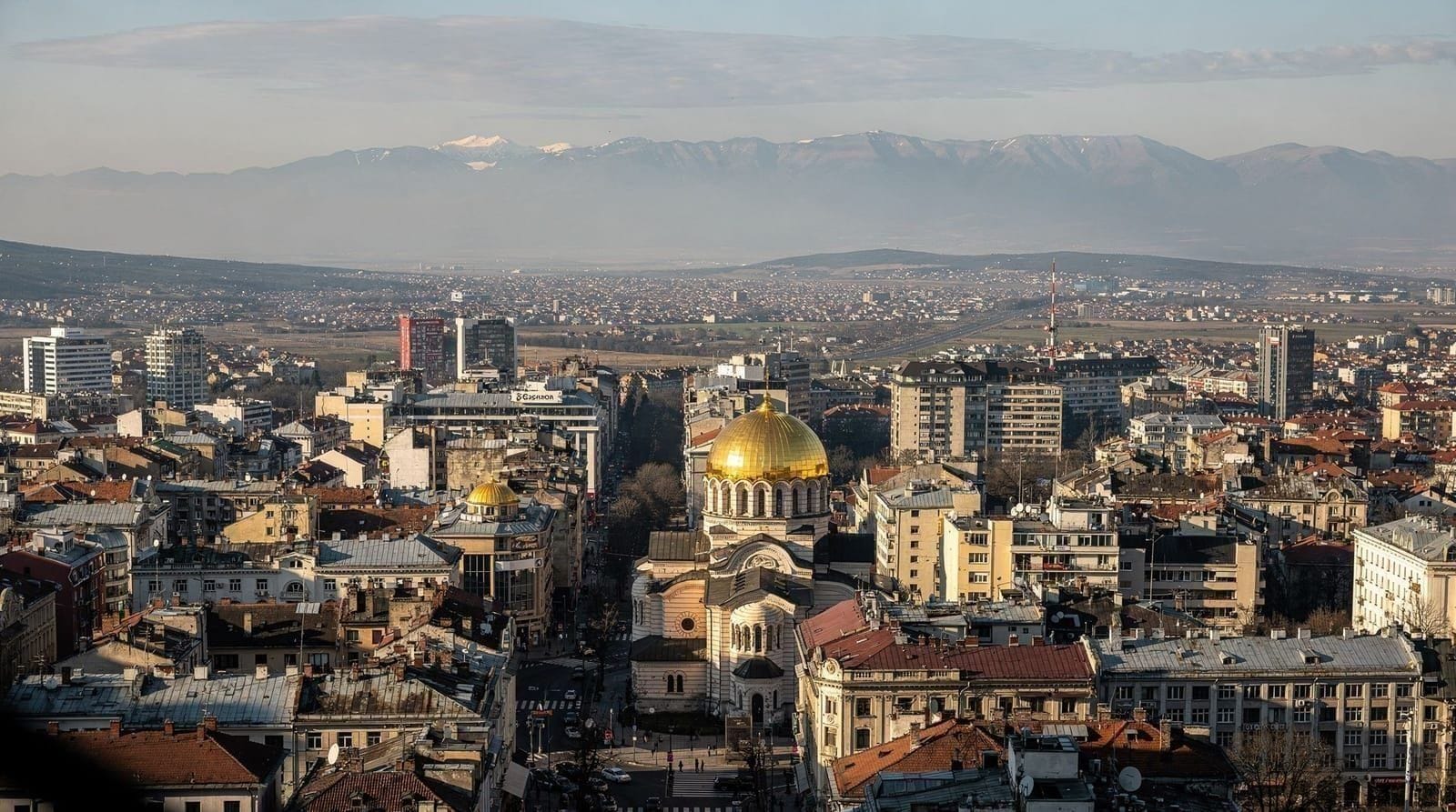
Vitosha is unusual among European capital cities: a 660 square kilometer national park begins roughly 30 minutes south of the city center by bus, rising to 2290 meters at its summit, Cherni Vruh (Black Peak). It is entirely possible to have breakfast in central Sofia and be walking through beech forest at 1200 meters before 10am.
The mountain is genuinely accessible — not just in distance, but logistically. Multiple bus lines run to trailheads. There is a gondola. Restaurants and huts sit at altitude. And the trails are well-marked and maintained by Bulgarian hiking standards.
What Vitosha is not: a mild park stroll. The summit requires fitness and proper footwear. Weather changes fast, snow can appear into May and return in October, and the ridge above 1800 meters is genuinely exposed. This guide covers the main routes honestly, including what can go wrong.
Vitosha facts and context
Vitosha became a national park in 1934, making it one of the oldest in the Balkans. The mountain is a granite pluton — a dome of volcanic rock — which gives it a rounded profile rather than sharp peaks. The summit, Cherni Vruh, sits at 2290 meters and is visible from much of Sofia on clear days.
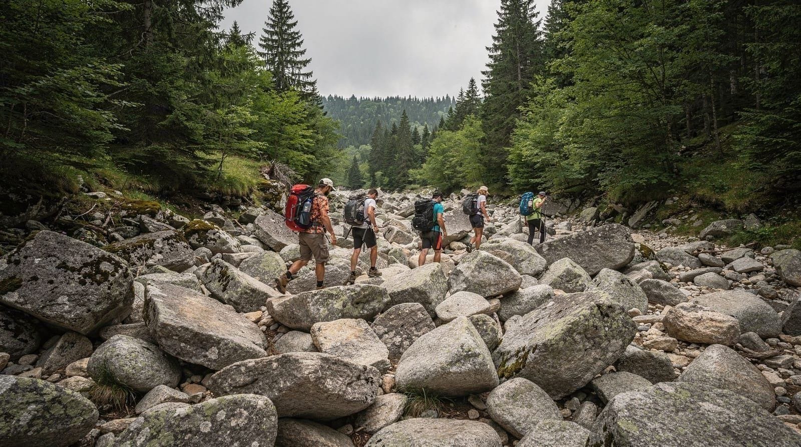
The most distinctive feature is the lapiashnik — giant boulder fields formed by periglacial processes during the last ice age. The Zlatni Mostove (Golden Bridges) area is the most accessible example, where boulders up to several meters across cover the hillside in slow-moving “stone rivers.” These are protected by national park rules: do not move or climb on them in damaging ways, though walking across them on the marked path is fine.
The mountain sits within the city limits of Sofia — an administrative fact that makes it the only national park directly inside a European capital.
Wildlife includes deer, wild boar, and occasional brown bear sightings in the upper zones. Bear encounters are rare. Make noise when walking through dense forest, which is standard practice throughout Bulgarian mountain areas.
Getting to Vitosha: the practical options
Bus 66 to Dragalevtsi and Zlatni Mostove
Bus 66 departs from Hadzhi Dimitar metro station (Line 2) roughly every 20-30 minutes. The journey to the Dragalevtsi terminus takes 25-35 minutes depending on traffic. From Dragalevtsi, a short walk uphill leads to the Dragalevtsi Monastery and the start of multiple trail routes. This is the most flexible access point — it puts you at around 700 meters with clear trail signs to all major routes.
For Zlatni Mostove specifically, you can continue on the bus past Dragalevtsi to the end of Bus 66’s mountain extension in summer. Check the Sofia Urban Mobility Centre (CUP Sofia) app for current routes and schedules, as bus 66’s mountain extension operates seasonally.
Bus 93 to Simeonovo Gondola Station
Bus 93 runs from the Hladilnika area (accessible by metro to James Bourchier station on Line 2) to the lower gondola station at Simeonovo. Journey time roughly 25 minutes.
The gondola (lift) takes you from the Simeonovo lower station to the Aleko Mountain Hut at approximately 1800 meters. This is the fastest way to reach altitude without hiking up. See the gondola section below.
Taxi or Bolt
A taxi or Bolt from central Sofia to the Dragalevtsi trailhead runs €8-12 depending on traffic. To the Simeonovo gondola station, expect €10-14. This is the fastest option and makes sense for early starts (before buses fill up) or for groups splitting the cost.
Car
Parking is available at Zlatni Mostove (limited, fills fast on weekends in summer) and near the Simeonovo gondola base. The road to Zlatni Mostove is paved but narrow in places.
The gondola (Simeonovo chairlift)
The Simeonovo gondola — technically a chairlift system — runs from the lower Simeonovo station to Aleko Hut at around 1800 meters. It operates primarily on weekends and public holidays, with limited weekday service in peak summer (July-August). The schedule changes by season and is subject to maintenance closures.
Price: approximately €6 return (€3.50 single). Pay at the station.
Capacity: it is a traditional open chairlift, meaning you are exposed to wind. At any season, carry a warm layer for the ride.
Reliability: the gondola closes for annual maintenance, often in spring or early autumn. Check the Vitosha National Park official site or the Sofia Urban Mobility Centre for current status before planning your day around it. Do not assume it will be running.
What you get: a straightforward connection to the top zone without the 3-hour uphill climb. From Aleko, you are a 2-hour hike from Cherni Vruh and have access to restaurant facilities and toilets.
Route 1: Zlatni Mostove (Golden Bridges) — family-friendly, no summit
Distance: 4-6 km round trip from bus stop, or longer if you continue upward
Elevation gain: 200-300 m from bus stop to the boulder field
Time: 2-3 hours for the flat circuit at the boulder field
Difficulty: easy to moderate; the path to the boulders is well-maintained
The Zlatni Mostove area sits at around 1450 meters and is the most visited part of Vitosha. The main draw is the lapiashnik — a wide boulder stream filling the valley floor. The path crosses the boulders on stepping stones; it is not technical but requires attention, especially if wet.
In autumn (late September to mid-October), this route is particularly good: the beech trees above the boulders turn gold and the light in the late afternoon is excellent for photography.
The Zlatni Mostove area has a small wooden shelter and sometimes a summer snack stall. Do not count on it being open.
From Zlatni Mostove, the main trail continues upward toward Cherni Vruh — adding 3+ hours of significant elevation gain. If you are doing Zlatni Mostove as a standalone family outing, turn around at the boulders.
Route 2: Cherni Vruh summit via Aleko
Distance: 6-7 km return from Aleko
Elevation gain: ~490 m (Aleko at ~1800m to Cherni Vruh at 2290m)
Time: 2 hours up, 1.5 hours down from Aleko
Difficulty: moderate to strenuous; the final ridge is exposed
This is the main summit route and the one most visitors do when they want to “do Vitosha properly.” Take the gondola from Simeonovo to Aleko, or hike up from a lower trailhead (add 3-4 hours and 1100m of elevation gain from Dragalevtsi).
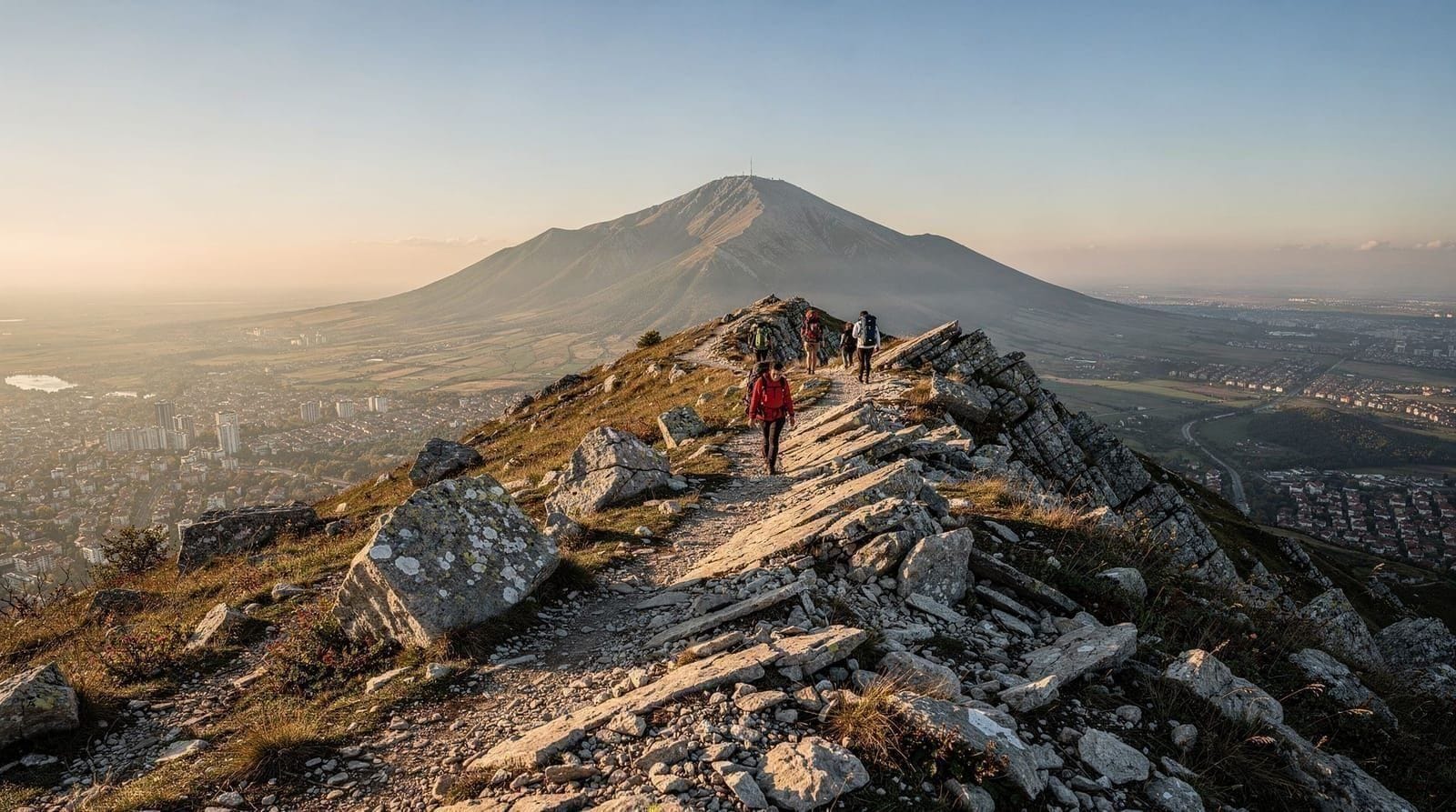
From Aleko, the path to Cherni Vruh is clearly marked. The first section climbs through subalpine meadows. The final kilometer is along an exposed ridge — wide enough and well-marked, but windy and cold even in summer. The summit is a plateau rather than a sharp peak, with a small weather station and a cross.
What you can see: on a clear day, Rila (including Musala, Bulgaria’s highest peak at 2925m), the Balkan Range to the north, and Sofia spread out below. Cloud cover at summit level is common by early afternoon — plan to reach the summit by 11am if possible for the best chance of clear views.
Important weather note: Vitosha is notorious for rapid weather changes. A sunny Sofia morning frequently means cloud and wind at 2000+ meters by noon. The ridge above 1900 meters can be seriously cold (sub-zero in spring, and temperatures can drop 10-15°C above the treeline compared to the city). Check the Bulgarian National Meteorological Institute (meteo.bg) forecast specifically for “Витоша” (Vitosha) before going up.
What to bring: waterproof jacket, warm mid-layer, hiking boots (not trainers on wet rock), water (no reliable water sources above Aleko), and food. Sunscreen at altitude regardless of cloud cover.
Route 3: Kopitoto via Dragalevtsi and Boyana
Distance: 10-14 km depending on starting point
Elevation gain: 500-700 m
Time: 3-4 hours one way from Dragalevtsi; full loop 5-7 hours
Difficulty: moderate
Kopitoto is the TV and radio tower visible from Sofia, sitting at roughly 1350 meters on the western flank of Vitosha. The route from Dragalevtsi passes through mixed forest and connects with the main path network. Alternatively, trails from the Boyana neighborhood (accessible by bus 64 from Hladilnika) lead up through the Boyana River gorge.
At Kopitoto itself, there is a restaurant with a panoramic terrace — this is a legitimate reward for the hike up, though the building is a Soviet-era concrete block. The terrace views toward Sofia, Plovdiv direction, and the lower mountain are good.
This route is better for weekdays when the busier Zlatni Mostove and Aleko areas feel crowded. It sees fewer hikers and has more genuine forest atmosphere.
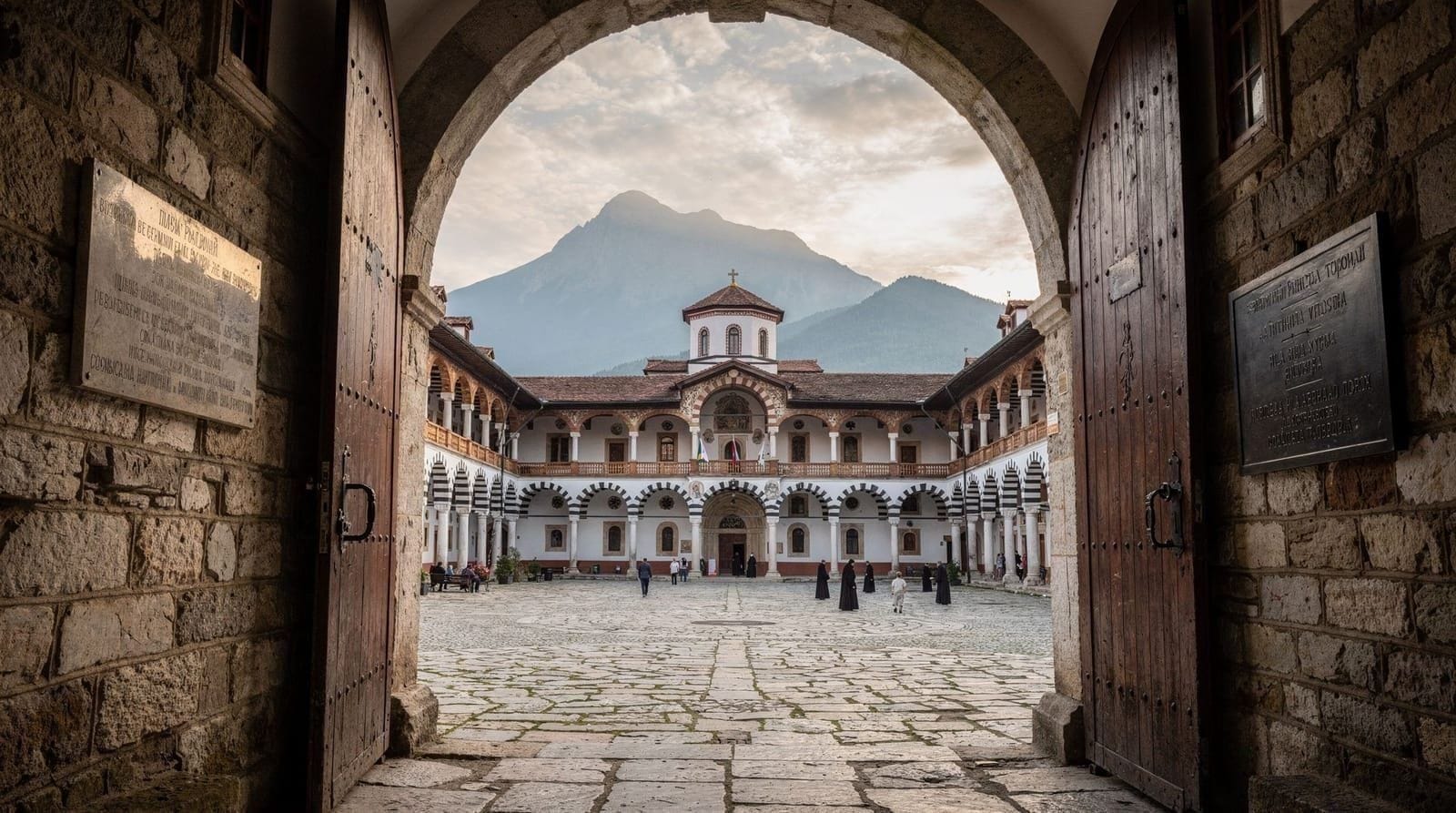
Dragalevtsi Monastery: a detour worth taking
The Dragalevtsi Monastery sits at the bottom of the forest, just uphill from the Dragalevtsi bus terminus on Bus 66. It dates to the 14th century (founded during the Second Bulgarian Empire), was rebuilt after Ottoman damage, and contains frescoes from multiple periods including some 15th-century originals.
The monastery is active and free to enter (donations welcome). It is small — you can see the whole thing in 20 minutes — but it is a good example of Bulgarian medieval religious architecture: a fortified stone wall enclosing a courtyard, a stone church with a wooden-roofed portico, and a small bell tower. The frescoes inside are partially damaged but preserve considerable detail.
Combine it with any of the above hikes as a 20-minute add-on at the start or end of the day. Opening hours are irregular; the gate is usually open during daylight.
Guided tours and organized hikes
If you prefer not to navigate independently, organized day hikes on Vitosha are available. These typically include transport from Sofia, a guide who knows the trails and flora, and the gondola if applicable. They are useful if you are unfamiliar with mountain environments or want someone to handle logistics.
Join a guided Vitosha day tour from SofiaFor more specific routes — including the Pancharevo Lake circuit on the eastern side of the mountain — guided options cover terrain that is harder to navigate independently.
Vitosha and Pancharevo Lake guided hikePractical tips
Timing: start early, especially for the summit. Cloud builds by noon. In July and August, trailheads and gondola queues can be long by 10am on weekends.
Footwear: hiking boots or trail runners with grip are necessary for anything above Zlatni Mostove. Trainers are fine for the Zlatni Mostove boulder walk in dry conditions. Never go above 1800m in regular shoes.
Mobile signal: good up to about 1500m on most Bulgarian networks. Above that, patchy. Download offline maps (Maps.me or Komoot work well for Vitosha) before you leave Sofia.
Water: carry at least 1.5 liters from the city. The springs in the lower forest are marked on maps but check their safety status — the Aleko hut sells water.
Bears: present but rarely encountered. Make noise when walking through dense low-visibility forest sections. If you see a bear, do not run; back away slowly.
Weather equipment checklist: waterproof jacket, warm layer, hat, gloves (even in June for the summit), sunscreen, water, snacks.
Frequently asked questions about Vitosha day hikes
Can I hike Vitosha without a guide?
Yes, and most people do. The trails are marked with colored paint blazes on trees and rocks, following the Bulgarian Mountain Tourism Union (BTSS) system. A yellow-blazed trail leads from Dragalevtsi to Zlatni Mostove; red marks the main summit route from Aleko. Download offline maps before leaving Sofia and you will have no navigation difficulties on the main routes.
Is the Vitosha gondola running?
The gondola operates primarily on weekends and public holidays, with some weekday service in summer. It closes annually for maintenance. Check meteo.bg or the Sofia Urban Mobility Centre website for current status — do not assume it will be open.
How difficult is the Cherni Vruh summit?
Moderate to strenuous. From Aleko (gondola top), the 490m climb takes about 2 hours and requires sustained effort. The final ridge is exposed to wind. It requires hiking boots and warm/waterproof layers. It is not technical climbing — you walk the whole way — but it is a proper mountain hike, not a park stroll.
What is the best time of year to hike Vitosha?
June through October for snow-free trails on the summit. July and August are the busiest months. Late September and October are excellent for autumn colour and cooler temperatures. The Zlatni Mostove boulder walk is manageable year-round on dry days; the summit route should be avoided November through April without mountain experience and proper equipment.
How do I get to Vitosha from central Sofia?
Bus 66 from Hadzhi Dimitar metro station to Dragalevtsi is the most common route (25-35 min, €1.60). Bus 93 from Hladilnika area to the Simeonovo gondola station is the alternative. Bolt or taxi to trailhead costs €8-14 from the center.
Are there restaurants on the mountain?
Yes. Aleko Hut at 1800m has a restaurant and basic accommodation. The Kopitoto TV tower area has a restaurant with terrace. Several mehani (traditional restaurants) operate at the lower Dragalevtsi area. Above Aleko, there is no food available — bring your own.
Is Vitosha safe for solo hikers?
Yes, on the main marked routes in good weather. The mountain sees thousands of visitors weekly and is well-patrolled by mountain rescue (Планинска спасителна служба — Planinska Spasitelna Sluzhba). The main risks are weather-related: check the forecast before going above the treeline. Let someone know your planned route if going alone to the summit.